
The purpose of this small package (see below for contents) is to give you a "jump-start" into the use of SuperCard for the purposes of making Dynamic Digital Maps (DDMs). I center the discussion in the tutorial around and introduce the parts of SuperCard that I have found to be most useful in making DDMs. This tutorial is not intended to be at all comprehensive, but rather to give you a feel for what is involved in using SuperCard for one specific use. As covered in the reprint of the April 1995 (GSA Today article), DDMs are not capable of making a map; that job is done outside of SuperCard, using standard programs such as word processors, spreadsheets and computer aided drafting programs (CADs). These maps and associated data are then inserted into a DDM which displays them, taking advantage of the computer environment and turning them into an interactive or "dynamic" map in the form of a stand-alone application.
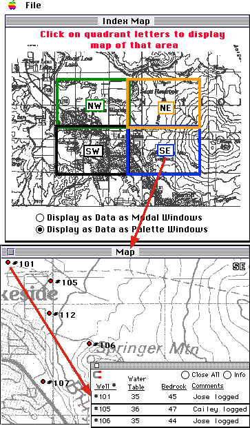 Shown at the left is the "Index Map" found within the SuperCard tutorial program. The user has selected the option "Display Data as Palette Wndows"., found at the bottom of this window. When the user clicks on the "SE Quadrant" label, the program brings up a detailed "Map" of that area, shown below. Found on that map are several "Well" sites. A click on a site diplays the associated data in a small palette window. In addition to intruducing you to the major components of a SuperCard project (program), the tutorial takes you through the process of adding a quadrangle map into the program, and shows you how to insert data for the well sites.
To use this tutorial you will need SuperCard version 2.5; because the interface for SuperCard 3.0 (which shipped in December 1996) is somewhat different, look for an update of this tutorial at the URL you are now browsing.
Download a copy of the this tutorial (Macintosh file, decompressed 240K), which includes:
1) A SuperCard (v.2.5) program (192 K).
2) A Microsoft Word (v.5.1) of the Tutorial Guide (24 K).
Two data files to be used with the tutorial:
4) A small (8 K) text data file: "WellLogData.txt", and
5) A small (40 K) Pict image: "SWMapSeg.Pict" which is part of a map to inserted into the SuperCard project while using the tutorial.
Return to Chris's page
|
|
Last revised 07 January 1997-- ccondit@geo.umass.edu |
|